Creating Historic Landscape Characterisations
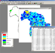
 The HLC dataset is created using a desk-based programme of GIS (computer based maps) mapping and analysis which draws on a wide variety of data sources. These include modern maps, historic maps, aerial photographs, place name studies, SMR data and local archaeological and historical knowledge and research.
You can download a short accessible introduction to the methodology adopted by the Cranborne Chase and West Wiltshire Downs HLC, as well as the full project methodology PDF documents below:
Short introduction PDF (160 Kb)
Full project methodology PDF (439 Kb)
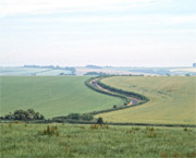
A national programme of Historic Landscape Characterisation was initiated by English Heritage in the early 1990s. All landscape within the British Isles can be said to be historic - there are hardly any areas, even apparently 'natural' ones, which man has not utilised or affected. The term historic landscape is therefore taken to encompass not just archaeological monuments and historic sites and buildings, but also roads and open spaces, fields, hedgerows, woodland and other habitats.
Over the past decade, HLC has evolved; there have been several 'waves' of the programme, each project developing and adapting the method to its own area. The English Heritage Characterisation pages provide an introduction to HLC as well as providing details of a methodological review undertaken by Aldred and Fairclough in 2003.
The Cranborne Chase and West Wiltshire Downs AONB HLC was completed in 2008 and followed the most up to date methodology.
 HLC is a relatively generalised characterisation designed to serve as a resource management tool. It
is not free-standing, or a replacement for other established datasets
(such as Sites and Monument Record's/Historic Environment Records or
other landscape assessments) but fills a gap in the available range
of conservation mechanisms.
HLC is a relatively generalised characterisation designed to serve as a resource management tool. It
is not free-standing, or a replacement for other established datasets
(such as Sites and Monument Record's/Historic Environment Records or
other landscape assessments) but fills a gap in the available range
of conservation mechanisms.
When the whole area has been mapped the newly created dataset can be queried and analysed to build up a comprehensive picture of the historic dimension of today's landscape.