Overview of the Historic Character of Fields in the AONB
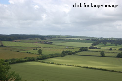
The photo on the right is the view west from Whitesheet Hill. It clearly demonstrates the physical effect the history of land use has on the landscape. On the right of the view is an area of regular pre 1800 enclosure leading towards the boundary of the former Kilmington common land in the distance. This contrasts markedly with the more irregular 19th century planned enclosure on the left.
The AONB is an extremely rural landscape, dominated by agriculture. The HLC has characterised enclosed land as covering 79% of today's landscape in the AONB. Fields therefore are a dominant feature of the landscape. The patterns that their boundaries and outlines create in the landscape form a major landscape component dominating most views of the AONB. They way individual fields and blocks of fields appear in the modern landscape has been created and shaped through successive stages of historic land use and agricultural activity. The process of the creation of the modern fieldscapes in the AONB has its origins with the open medieval strip fields which remain fossilised as enclosed fields in the landscape today. From the Medieval period onwards new irregular piecemeal fields were created from open land and the assarting of ancient forest became increasingly common. The first formally arranged and larger scale attempts at enclosure occurred from the 16th Century onwards and became politically formalised with the parliamentary enclosure acts of the 19th century. In the 20th century this process accelerated with the creation of large prairie fields and the reorganisation of existing field systems.
These individual examples of differing land use history build up to create the overall pattern of fields in the AONB.
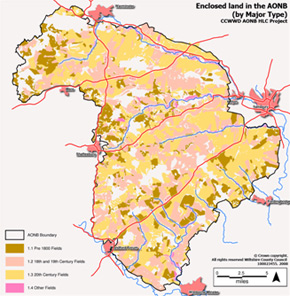
The map shows the fields which exist in today's landscape displayed by Major Type.
This map illustrates that there are notable concentrations of pre 1800 fields along the Greensand Terraces and Hills between Mere and Warminster, in the Vale of Wardour and to the south of the A354. These fields, and other features in this area, are of considerable antiquity.
Click map for large PDF version (378Kb)
In contrast late 18th and 19th century fields are widely distributed throughout the AONB with slightly higher concentrations occurring in the area around the Ebble valley and on the West Wiltshire Downs. These fields mark a time of great upheaval and change in the landscape, when common rights were extinguished and large swathes of formerly open chalk downland enclosed. The evidence for this upheaval takes a range of forms and has been created by a range of processes and includes replanned fields, fields created by agreement, and parliamentary enclosure.
The impact of 20th century changes on the landscape can largely be linked to large scale changes in agricultural practice and the intensification of farming. In the present day 20th century fields account for 34% of the AONB, they are widely distributed across the AONB but are largely absent from the far north-western edge. These fields have come about through the creation of new fields, through modifying existing field layouts, and finally through amalgamation, where existing field boundaries are removed to create new larger fields. In general terms there has been a trend over the last 100 years for an increase in the number of fields present in the AONB.
For more detailed information on the AONB Historic Landscape Characterisation click here.