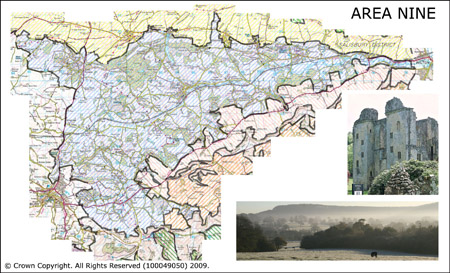
Area 9 Vale of Wardour
Area 9 comprises the Vale of Wardour which occupies a central location in the area. It is bounded by the West Wiltshire Downs to the north and the chalk escarpments to the south. The vale of Wardour is a rolling clay valley defined by a mix of pasture and arable crops which contrasts markedly with the land to the north and south. The River Nadder flows west to east across the area towards the Avon and contradicts the landform which becomes wider and less narrow to the west. The edges of the Vale of Wardour are formed of an undulating band of greensand hills which are clothed in woodland in places with a mosaic of permanent pasture and woodland in others.
 Summary Description
- This area is characterised by a mixed pattern of Historic Landscape Character Types which are arranged in a mosaic across the area.This includes historic fields dating to before 1800.
- Common land survives around Semley and other common land to the south has scrubbed up.
- There is an ancient and dense pattern of routeways.
- The ruins of Wardour Castle are an important tourist attraction.
- There are many historic parks and gardens as well as former deer parks.
- The Nadder has relic water meadows along its length.
- The area is crossed by the railway.
- Stone quarries are an important historic feature.
The full Historic Landscape Character Area description is available to download from the Historic Environment Action Plan Pages