Water in the Landscape
 The former use of water meadows and mills, and the creation of ponds and lakes have all had an impact on the landscape of the AONB seen today
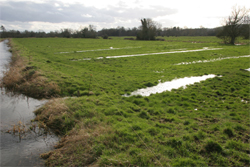
There is evidence for relic water meadows stretching along the bottom of all the chalk river valleys in the AONB including bedworks, sluices and bridges. These provide evidence for the former crucial role of the sheep-corn system of agriculture in the AONB from AD 1600 to AD 1900.
Systems of fish ponds and small man-made lakes are associated with chalk rivers and river valley bottoms, many of these have Medieval origins, but some also forming modern heavily designed commercial fish farms. Man-made lakes are associated with the creation of 'formal' designed landscapes of the 18th and 19th century's, including Fonthill and the pleasure lake at Shearwater - these are much more common in the northern half of the AONB.
Former mill buildings,are scattered through the river valleys including remnants of water wheels, mill races and mill ponds in chalk river valleys. These all mark evidence of former exploitation of water power in the valleys.
There are several operational watercress beds in the AONB marking the remnants of a once much more thriving industry in the chalk river valleys.
There is some evidence for the manipulation of the chalk rivers' especially where they flow through settlements - here the chalk rivers are contained in stone sided channels and the houses are often located on the opposing bank to the historic routeways, each with an individual stone bridge. The villages are associated with historic 'river' crossing points, including fords and clapper bridges.
More information on the historic woodlands of the AONB can be accessed by clicking here: Theme 12: Water in the Landscape.
This document forms part of the wider AONB Historic Environment Action Plans.
